
This is another post about Newcastle history and old maps (my last was about chares); it is the story of the decline and loss of what was once the nicest place in Newcastle.
My interest in Newcastle’s ‘Forth’ was sparked when doing some work on OpenStreetMap: after mapping the now-derelict Forth Goods Yard west of the station, I noticed how many nearby streets had Forth in the name. There’s the steep Forth Banks which connects to Forth Street, and there’s Forth Place and Forth Lane, at the corner of which is the Forth pub with its space invader (NCL_13). Clearly the name referred to something important.
Looking at some older maps, I opened Corbridge’s map of 1723, and there is is: a tree-lined square labelled The Forth, south of the Forth Gate, which was between Gunner Tower and Pink Tower (Pink Lane, which still exists, ran just inside the town wall between these two towers).
Mackenzie’s history of Newcastle relates the history of The Forth from various earlier sources. It was in use by the 1500s, being used for the playing of bowls and archery. It began as a square field of over four acres, fenced to keep animals out, and used by people of all ages for their leisure: a playground for children, dancing square, ‘trysting ground’ for lovers, meeting place for the guilds before they built their own guild halls, and a place for the old to stroll and enjoy the view.
Sited above the steep part of the Tyne Gorge but well outside the town, it must have had the best views in the area, across the Team Valley to the south and the Tyne valley to the west. Away from the noise of workshops and the stink of tanneries and open sewers, it must have been a paradise for the Elizabethan townsfolk. By the early 1700s it was reached by a tree-lined walk from the Forth Gate, and double rows of lime trees from Holland were planted to shade the walk around the four sides of the green space. Sporting events took place in a field to the south (marked on some maps as the Forth Field), and further south, in what is now the almost-forgotten Redheugh Bridge Park, wrestling matches took place.
I’m not completely sure where the name Forth comes from. Place names that include forth are usually related to fords, and the site was about halfway between the town wall and the Skinnerburn, so it could have been named after a route that crossed that river by a ford. Alternatively, since it was outside the town wall, the inhabitants had to ‘go forth’ through the wall to reach it.
For hundreds of years, at Easter and at Whitsuntide, the mayor and aldermen of the town would go in a grand procession to the Forth, with the mace and all the symbols of the town corporation, which shows what an important place the Forth was. By the 1600s the land was formally recognised as common land, and widely used for airing clothing (impossible in medieval streets so narrow that the tops of the houses on each side almost met). A house was built on the north side, at public expense, for the keeper of the bowling green. After the Restoration, the Forth House was extended, becoming a large and welcoming tavern which can be seen on the 1723 map above.
Sadly, it was mostly downhill after that. Use of the field for military training degraded it, and the lime trees died over time; in 1802 the town council banned the use of the Forth for anything but leisure and replaced the lines of trees. But now factories were being built along the valuable land adjacent to the river, and Newcastle’s population was exploding, spreading far beyond the crumbling town wall. Within a few more decades, the Forth had lost its views, was no longer quiet, the tavern of 1680 was falling down, and pressure of population was becoming overwhelming. What had begun as a small cattle market alongside the Forth needed more space, and in 1842 the last tree was uprooted as the cattle market was expanded into the Forth, which was no longer recognisable as a place of leisure.
From the 1840s to the 1960s, Newcastle’s corporation pursued, with destructive zeal, a policy of tearing down anything that stood in the way of development. History was never obliterated faster than during the 1840s and the 1960s. Nowadays, things have changed, and the city council’s plan for the ‘Forth Yards Opportunity Site’ demands that developers keep all features that have roots in the site’s industrial history; the disused railway line alongside the former Forth Goods Yard is going to be turned into a pedestrian and cycle path like the High Line.
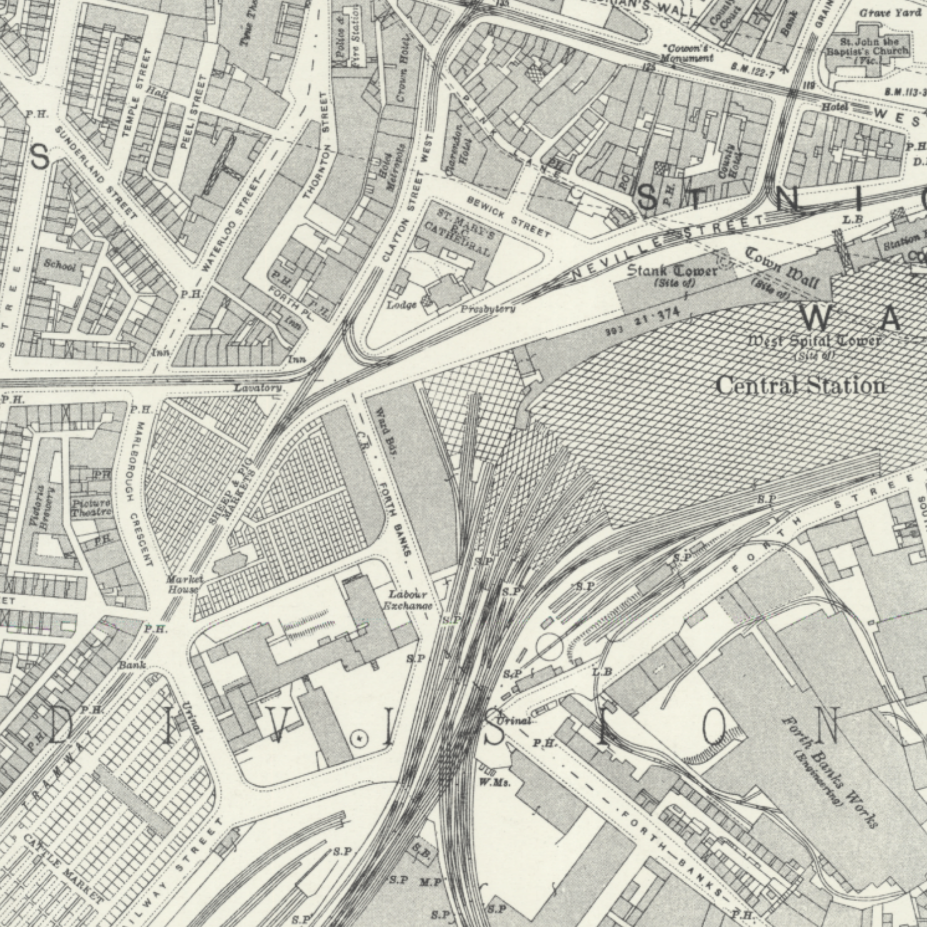
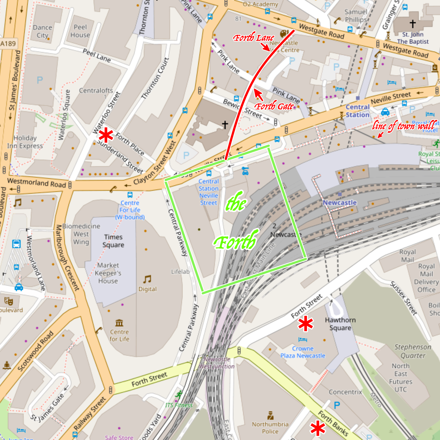
So where exactly, I wondered, was the fabled Forth, which for centuries was the loveliest place in Newcastle? It can be located by comparing old maps and newer ones, because other nearby features survive, while the Forth itself did not. Maps from 1838 are the last to show the Forth Walk, with the top section of Forth Banks forming its western side. Forth House was still there, just southeast of Forth Place which still exists today.
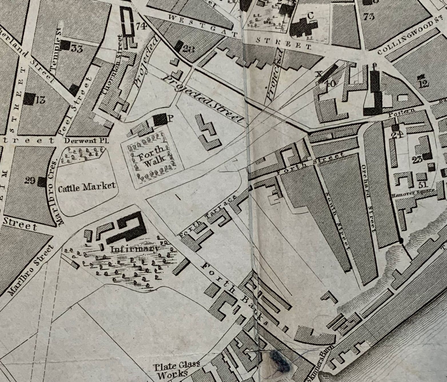
Marlbrough Crescent, on the west side of the Cattle Market (now superseded by the Centre for Life), also still exists today. The street on the east side of the cattle market is nowadays called Central Parkway, a suffocatingly bland name which must have surely been thought up by a bored PR consultant. But on the 1892 OS map, it was still considered part of Forth Banks, which passes the Cattle Market and goes all the way up to Forth Place.
Given that the Forth was recorded in 1649 as consisting of four acres and one rood, that would be a square of about 130m each side. The former railway building east of Central Parkway, now a creche, is about 100m long, so here’s my best guess where the Forth once was:
So there we are: the railway was not only driven right through the middle of the castle, but was also built on Newcastle’s finest park, or rather its pathetic remains.
I’m not quite sure what I find so compelling about the sad story of the Forth. I suppose it’s a combination of things: solving the mystery of where it was and what happened to it; pride in Newcastle (what other city had a fine public park and bowling green with a fantastic view, maintained for the common good by the corporation, 500 years ago?); the interest of learning more about life before the industrial revolution; and my ongoing interest in how traces of the past can be seen in the landscapes of today, if you know where to look.
The Forth may be gone, but as an example of the past shaping the present, today’s Thomas Bewick Square exists only because a gate through the town wall was made on that spot in the reign of Queen Anne, so that people could go more directly to their Forth to enjoy a stroll around the shady square of trees, listen to the songs of birds, and gaze across the Tyne valley to the unspoilt uplands beyond.