
Following my map research last month, I grew increasingly interested in Newcastle's geography and how it came into being. As I wander around the town looking for space invaders and things to improve on OpenStreetMap, I've noticed nearly a dozen small streets which don't appear on Google or Apple maps: central Newcastle streets (with City Council name plates) like Drury Lane, Whitefriars Place and Albion Yard. They now appear on OSM, of course. Looking at the 19th century OS maps, there used to be hundreds more. Each city block in what is now Grainger Town had dozens, but many of them have been built over with much larger buildings subsequently.
Ever since childhood, I've loved exploring the narrow, hidden spaces in the urban environment: gaps between buildings and little alleyways connecting two streets, often overgrown and almost disused. Where I grew up, these little connecting passages were called snickets, but in other places they are called ginnels, alleys, cut-throughs or wynds. In Newcastle, uniquely, they are called chares. Most often, they can't be built upon because they are public rights of way, and usually have been since the middle ages. Newcastle has been inhabited since Roman times and the street layout in the oldest part of town (close by the castle) has remained largely unchanged since Norman times. The Roman layout also still has its influence, with Westgate Road following the exact line of Hadrian's Wall for miles, and their Great North Road, leading into Northumberland, still present in today's Northumberland Street.
But it's the imaginitive possibilities of unseen alleyways I like best. When my family moved to a market town, when I was 13, I was thrilled to find so many quiet little shortcuts between the main roads (all dating back to the time when the town had a castle and a town wall) with names like Star Yard and Hole In The Wall. The darker and more overgrown these paths, the more I loved them, and I still do. Newcastle is rich with them, and a hundred years ago had ten times as many, I know from maps.
My ongoing interest led me to delve into some of the Lit & Phil's older maps. Poring over these, I spotted a familiar pattern, which can be found everywhere in England. In mediaeval towns, land was often divided into strips, each strip having one house and enough land to feed one family. The houses typically stood along a road, which was level, running along a countour; while the strips were at right-angles to the road, running slightly up or downhill, for drainage. The house I was born in stood on exactly such a strip, and the town house we later moved to was in the lower half of a strip which had been divided for building purposes; but many of the neighbouring houses still had their complete strip, with long, narrow gardens. These are burgage plots, and they are narrow because space on the main road (especially a marketplace) was at a premium, so more money could be made by selling off land in this shape. (A man who owned land in a town, and could therefore vote for its sheriff and other officers, was a burgess.) They are to be found all over England alongside those roads which existed in the middle ages. In the north of England, most of these roads have names ending in Market or Gate (the Norse word for street).
This pattern can most clearly be seen alongside Pilgrim Street in this map of 1736, and also along Westgate Street and Newgate Street (both named for gates in the city wall; the New Gate was a more strongly-fortified replacement for an earlier town gate, and was at this period used as the town's prison).
I noticed that something interesting (which I haven't seen in smaller towns) had happened to these burgage strips during the industrial revolution. All the gardens were built on, but lacking top-down planning or the investment to buy up several strips, they were each built on separately, retaining the mediaeval property boundaries. This map of 1861 shows how a series of strips along Newgate Street (the city block I now live in) have each been built in, by constructing buildings, most often around the three outer edges of the strip, accessed through a narrow courtyard. They are almost always called somebody's Yard or something Court (few names are on this large-scale map; but you can see the Albion Inn, which I guess gave its name to today's Albion Yard). The buildings on Newgate Street are continuous, the back yards being accessed via passages under the first floor of the building, maximising the value of both the road-fronting and the back land. In the mid 19th century, Newcastle must have had hundreds of these courtyards.
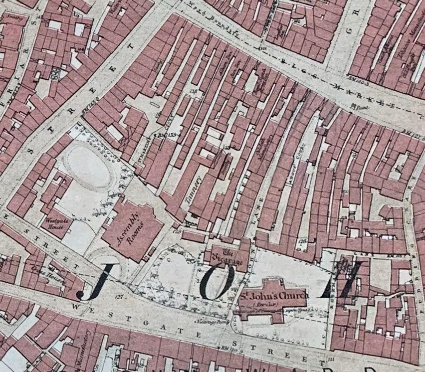
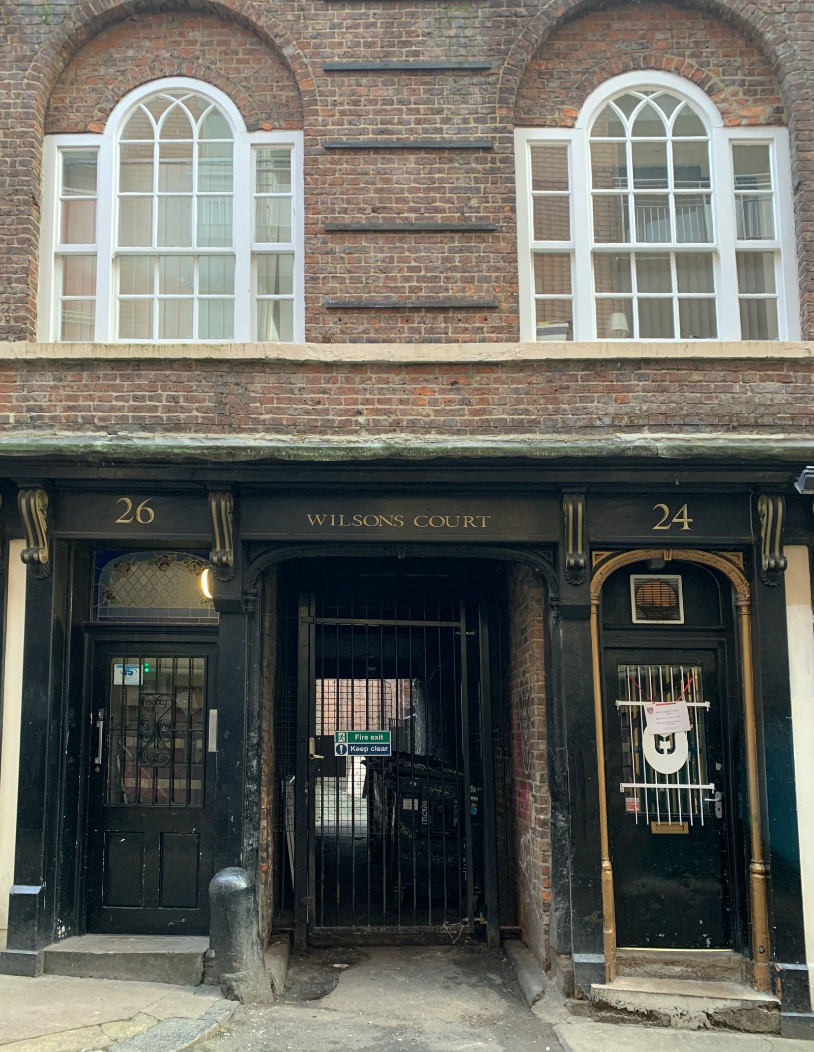
All of the courts in that block have now gone, probably wiped away by the Newgate Shopping Centre in the 1960s, but the entrance to Wilson's Court, off Pudding Chare, shows how they would all have looked (probably without the gate).
But while these private Yards and Courts developed in the early part of the industrial revolution, Chares go back much further, being customary rights of way. On the quayside, the burgage strips had been fully built on by 1736, and alleys run between the buildings. Many of these survive to this day, with names like Broad Chare, Plummer Chare and Trinity Chare. In 1827 there were 20 chares leading to the quayside alone. Even then, the historian Mackenzie notes that many, like Pudding Chare off the Bigg Market were “narrow, dirty, and inconvenient for carriages”. Some names have changed: what is now Rosemary Lane was originally St. John's Chare, and Pudding Chare itself was originally Budding Chare, according to the earlier historian Bourne. Mackenzie records over a dozen chares which had gone by 1827, and more were erased in the rebuilding after the great fire of 1854.
In the middle ages, many of these chares were almost dark, since the upper stories of buildings on either side almost met; had no sewers whatsoever until late in the Victorian era; and were lawless or at least deeply disreputable. Mackenzie notes that “one of these chares, in the reign of King Henry VI was known by a very immodest appellation, which shews the indelicacy of the times.” My guess would be Gropecunt Lane since Newcastle is known to have had one, like many other English towns. Sex, smuggling and the poor escaping from the laws of the rich through a crepuscular maze of streets with quaint names are tinder for the imagination, I'm happy to be able to go nosing into these streets (in the safety of daylight and modern policing) looking for traces of the past.
The fact that every era of Newcastle's history - Roman walls, the Norman castle, mediaeval town walls and priories, fine Georgian and Victorian and Edwardian buildings - can be seen just by wandering around the city is one of the things I like most about Newcastle. I never thought I'd find myself staying up until midnight avidly reading up on the history of the town. But life, like big cities, is full of surprises.