
What makes a place, a place? Can somewhere be a place if it doesn’t have a name?
If you asked anyone who lives in Newcastle where Shieldfield is, my guess is most people would know. It’s close to the city centre, and nowadays lots of students live there. But if you asked people where Battle Field is, my impression is that few people have heard of it. On maps, it’s the area south and east of Shieldfield, but the name doesn’t seem to be in common currency. Meanwhile, when I tell people I live in a place called Quayside, everyone knows where that is, even though the name doesn’t appear on most maps.
Does having a history make a place, then? Shieldfield appears on early medieval maps; I have read that the name denotes a shelter in a clearing. Battlefield sounds like it could be medieval too, but it isn’t. Here’s a fragment of a map from 1833. The building numbered 58 is St. Ann’s Church, and to the north of it (north is about 30° clockwise from vertical on this map), east of Elwicks Lane, are nothing but fields.
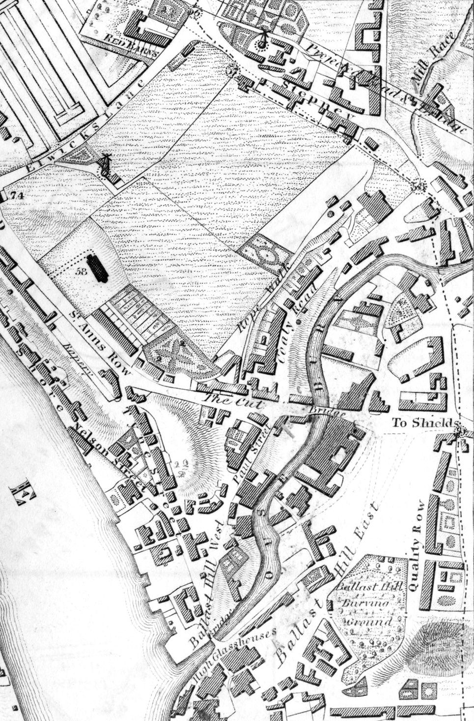
What I’ve always found especially interesting about this 1833 map is that it shows some proposed roads, some of which were built and some weren’t. On this excerpt you can see the proposed route of Byker Bridge, which wasn’t built until 1878.
Then for comparison, here’s the OS map of about 1900. (Open the image in a new tab to see it in more detail.)
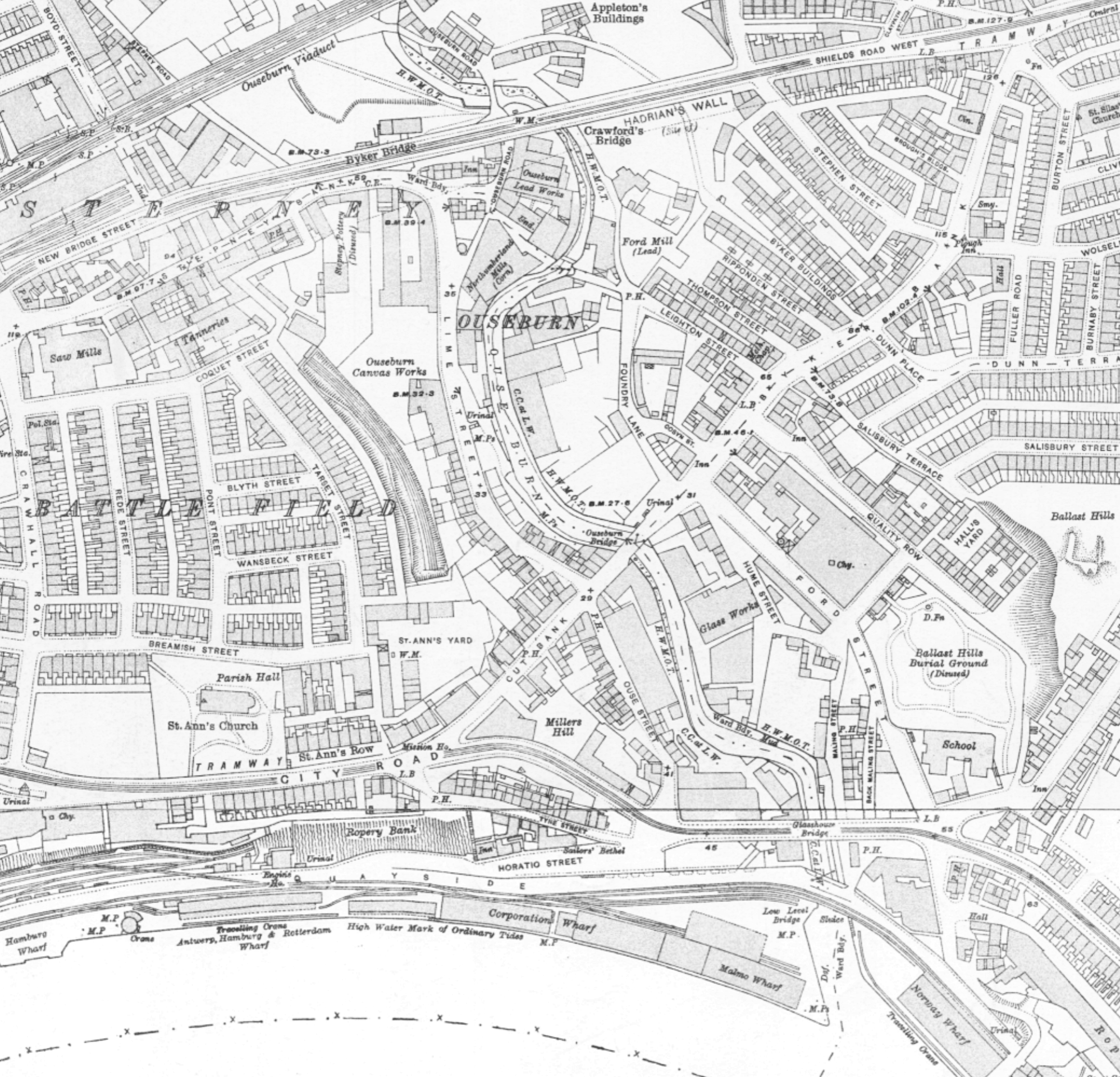
On the left-hand edge of the map, Elwicks Lane has been renamed Crawhall Road, and to the east of it is a built-up area named Battle Field. Where did that come from?
The answer lies just to the east, in Ouseburn valley. Before big, heavy industries came to Newcastle, rather late in the Industrial Revolution, smaller industries were springing up, many of them along the Ouseburn, which is tidal up to a point just north of the railway viaduct (the exact point where it emerges from a culvert today). There were many lead works, glass works and potteries. Potteries need clay which was dug from the fields north of St. Ann’s. And after a few years of that, the fields resembled a battlefield! It’s a jokey name, very Geordie.
Apart from a row of houses on the south side of City Road opposite St. Ann’s, nobody ever lived between City Road and the river Tyne; it was all commercial, with wharves and warehouses and a railway goods yard (bottom left in the 1900 map; the line serving it passes through a tunnel under City Road and St. Ann’s Yard, emerging to form the eastern boundary of Battle Field). If a name was needed, they probably called it part of Battle Field. The warehouses persisted until the 1980s, and then things changed.
In 1986, the first Tall Ships event gave many their first ever reason to visit Newcastle’s quayside, which was now largely abandoned. And then in 1987, a Conservative government anxious to divert development funds away from the Labour city council set up the Tyne & Wear Development Corporation. Adding to the new Law Courts which opened in 1990, it planned a cinema, luxury hotel, casino, high-end retail, and up to 100 “executive housing units” for the quayside between the Tyne Bridge and Ouseburn. The cinema was never built, the casino didn’t last long (it’s now Barclays), but there was a demand for office blocks, and even more demand for housing, and now quite a lot of people live on or close to the quayside south of City Road. The last two undeveloped plots, Quayside 12 and Malmo Quay, are certain to be used for housing too.
Meanwhile, Gateshead has been equally successful redeveloping the opposite bank, with the Sage, the Baltic and above all the Millennium Bridge bringing hordes of tourists to the quayside – in fact probably almost all tourists to Newcastle-Gateshead come to the quayside, because it’s simply the most eye-catching and beautiful part of either city. So the name Quayside has, without any official endorsement, attached itself to the area.
Here’s a brilliant aerial photo of the Quayside, half-way between being nowhere in particular and becoming a place. We’re looking east: the Ouseburn is at the top and Byker Bridge top left.
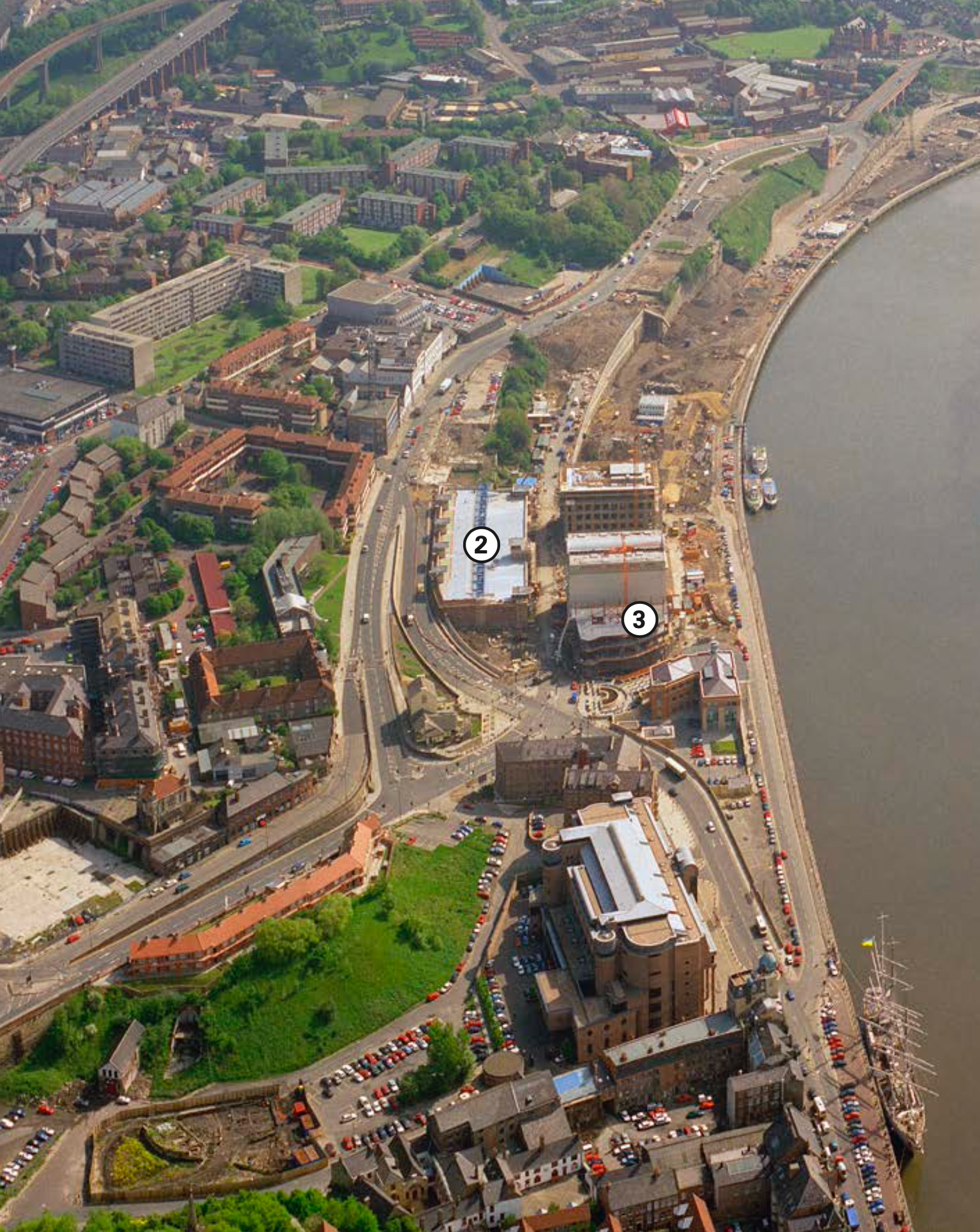
The number 2 labels the quayside car park under construction (nowadays new developments never get huge car parks), and 3 shows the first big office blocks being built. The rest of the quayside has been cleared in readiness, except for the historical Sailors Bethel building top right, and the Co-Operative building which is now Malmaison. The Law Courts are in the foreground, with a tall ship moored opposite Broad Chare. It’s a fascinating snapshot of a new place coming into being. And that doesn’t happen very often any more.
Image credits: the aerial photo above is from The Regeneration of Newcastle/Gateshead Quays by Eric Morgan. The blog cover image is an excerpt from Bing Maps, the only map I could find which labels the Quayside with any name.